File:The Cherokee Land Lottery - Forward, page 1.jpg
Jump to navigation
Jump to search
Size of this preview: 369 × 600 pixels. Other resolutions: 147 × 240 pixels | 951 × 1,546 pixels.
Original file (951 × 1,546 pixels, file size: 272 KB, MIME type: image/jpeg)
Citation
Source Listing
Smith, James F. The Cherokee Land Lottery, Containing a Numerical List of the Names of the Fortunate Drawers in Said Lottery, With an Engraved Map of Each District. New York, Harper & Brothers, 1838. Digital images. Internet Archive, https://archive.org/details/cherokeelandlott00smit: 2009.
Citation Listing
James F. Smith, The Cherokee Land Lottery, Containing a Numerical List of the Names of the Fortunate Drawers in Said Lottery, With an Engraved Map of Each District (New York, Harper & Brothers, 1838), unnumbered p. vii for map "The Land Area of the Cherokee Lottery"; digital images, Internet Archive (https://archive.org/details/cherokeelandlott00smit : accessed 25 December 2017), image 15 of 626.
Subsequent Note
Smith, Cherokee Land Lottery, unnumbered p. vii, for forward.
Link to Citation
- Citation:The Cherokee land lottery, containing a numerical list of the names of the fortunate drawers in said lottery, with an engraved map of each district/Source Listing
- Citation:The Cherokee Land Lottery - Forward, page 1.jpg/Citation Listing
- Citation:The Cherokee Land Lottery - Forward, page 1.jpg/Subsequent Note
 ==Wiki Codes==
 Source Listing:
 {{Citation:The Cherokee land lottery, containing a numerical list of the names of the fortunate drawers in said lottery, with an engraved map of each district/Source Listing}}
 Citation Listing:
 {{Citation:The Cherokee Land Lottery - Forward, page 1.jpg/Citation Listing}}
 Subsequent Note:
 {{Citation:The Cherokee Land Lottery - Forward, page 1.jpg/Subsequent Note}}
Notes
Transcription
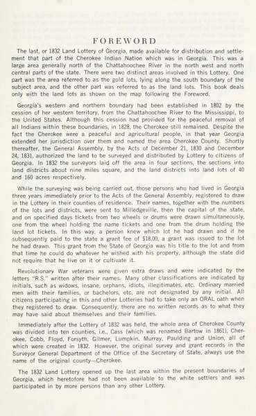
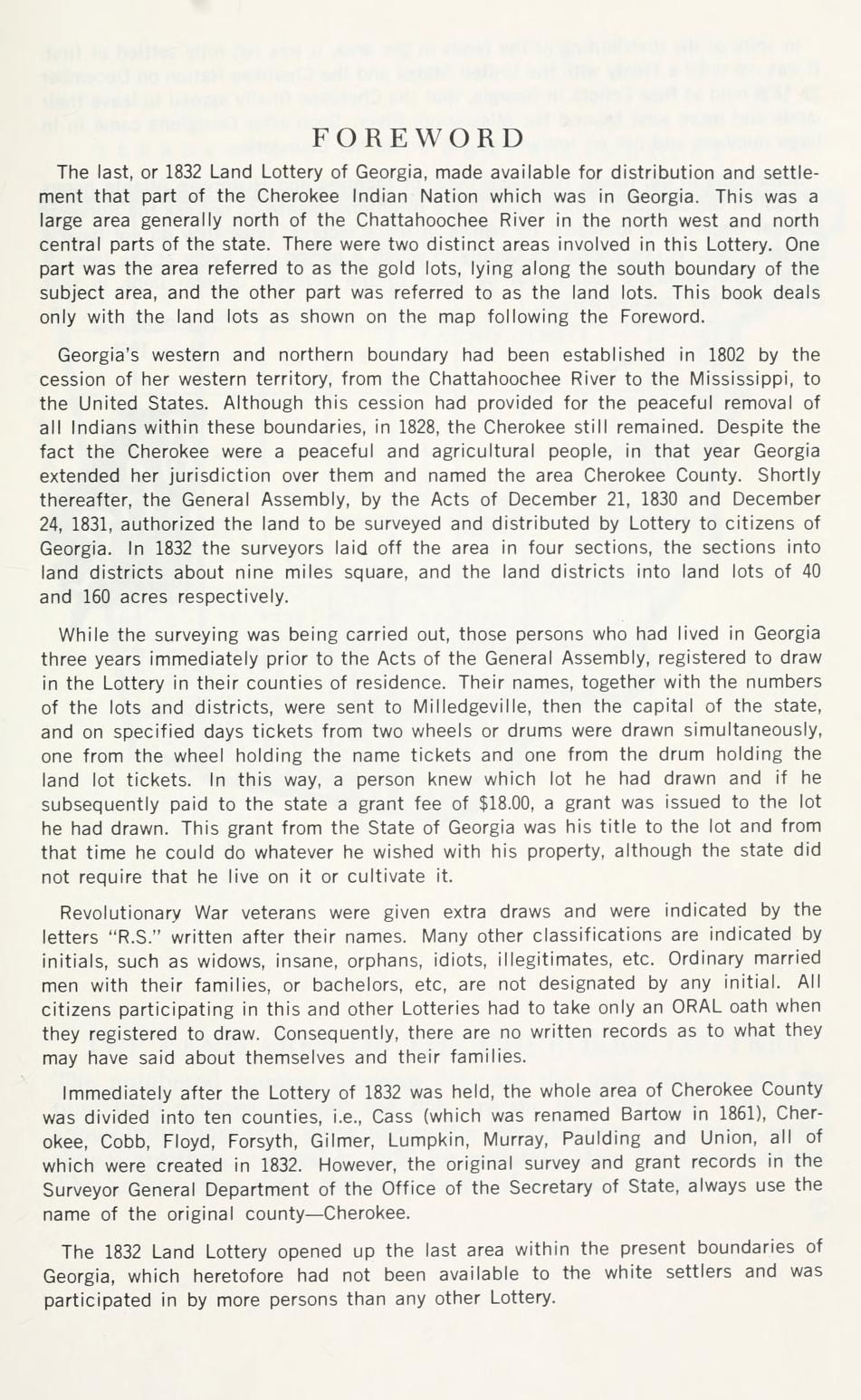
F O R E W O R D

The last or 1832 Land Lottery of Georgia, made available for distribution and settle-
ment that part of the Cherokee Indian Nation which was in Georgia. This was a
large area generally north at the Chattahoochee River in the north west and north
central parts of the state. There were two distinct areas involved in this Lottery. One
part was the area referred to as the gold lots, lying along the south boundary of the
subject area, and the other part was referred to as the land lots. This book deals
only with the land lots as shown on the map following the Foreword.

Georgia's western and northern boundary had been established in 1802 by the
cession of her western territory, from the Chattahoochee River to the Mississippi, to
the United States. Although this cession had provided for the peaceful removal of
all Indians within these boundaries, in 1828, the Cherokee still remained. Despite the
fact the Cherokee were a peaceful and agricultural people, in that year Georgia
extended her jurisdiction over them and named the area Cherokee County. Shortly
thereafter, the General Assembly, by the Acts at December 21, 1830 and December
24. 1831. authorized the land to be surveyed and distributed by Lottery to citizens or
Georgia. In 1832 the surveyors laid oft the area in four sections, the sections into
land districts about nine miles square, and the land distracts into land lots of 40
and 160 acres respectively.

While the surveying was being carried out, those persons who had lived in Georgia
three years immediately prior to the Acts or the General Assembly, registered to draw
in the Lottery in their counties of residence. Their names, together with the numbers
or the lots and districts, were sent to Milledeville, then the capital at the state,
and on specified days tickets from two wheels or drums were drawn simultaneously.
one from the wheel holding the name tickets and one from the drum holding the
land lot tickets. In this way, a person knew which lot he had drawn and it he
subsequently paid to the state a grant tee or $18.00, a grant was issued to the lot
he had drawn. This grant from the State or Georgia was his title to the lot and from
that time he could do whatever he wished with his property, although the state did
not require that he live on it or cultivate it.

Revolutionary War veterans were given extra draws and were indicated by the
letters “R.S." written after their names. Many other classifications are indicated by
initials, such as widows, insane, orphans, idiots, legitimates. etc. Ordinary married
men with their families, or bachelors, etc, are not designated by any initial. All
citizens participating in this and other Lotteries had to take only an ORAL oath when
they registered to draw. Consequently. there are no written records as to what they
may have said about themselves and their families.

Immediately alter the Lottery or 1832 was held, the whole area or Cherokee County
was divided into ten counties. i.e., Cass [which was renamed Bartow in 1861), Cher-
okee. Cobb. Floyd. Forsyth. Gilmer, Lumpkin, Murray, Paulding and Union, all of
which were created in 1832. However, the original survey and grant records in the
Surveyor General Department of the Office of the secretary or state, always use the
name or the original county-Cherokee.

The 1832 Land Lottery opened up the last area within the present boundaries at
Georgia. which heretofore had not been available to the white settlers and was
participated in try more persons than any other Lottery.
File history
Click on a date/time to view the file as it appeared at that time.
| Date/Time | Thumbnail | Dimensions | User | Comment | |
|---|---|---|---|---|---|
| current | 12:36, 27 April 2013 | | 951 × 1,546 (272 KB) | Wikiadmin (talk | contribs) | MsUpload |
You cannot overwrite this file.